I spent yesterday in the National Army Museum looking for material which would be of interest to the City Lit Summer school I am tutoring on the Battle of Waterloo. The collection is fascinating. It is one thing to read the accounts in books. Its another to hold in your hands the letters and diaries of the soldiers of the time; or to see the some of the paintings in their reserve collection, and the preliminary sketches of the battlefield by the artists.
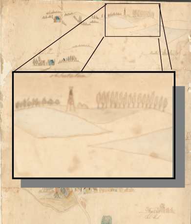
One intriguing object is a water colour sketch map, with the inscription “used on the battlefield”. The archive staff had no information about the provenance of the item, which had once been framed. The sketch map shows some of the key terrain features visible from the Anglo-Dutch position, including the village of Mont St Jean, the farm of the same name, the villages where the Anglo Dutch Army deployed, Hougoumont, Mon Plaisir and La Haye Sainte and the ridge lines in the French positions. Intriguingly, the map did not have some of the terrain features that appear on battle maps to explain the course of the battle. So the village of Placenoit is not marked. Nor is the track running across the front of the Anglo Dutch position, the famous sunken road. So maybe this map was one produced by Wellington’s staff on the day for orientation purposes. ( “The farm in the dip a couple of hundred paces in front of us is called La Haye Saint and the chateau on our right about a mile away on the right hand side of the walled garden is Hougoumont”) One distinctive feature shown is an observation tower south of Hougoumont and East of the Mont Plaisir Farm. Its an obvious feature, and one that also appears in some of the pen and ink sketches made by the painter Richard Dighton of the battlefield after the battle.
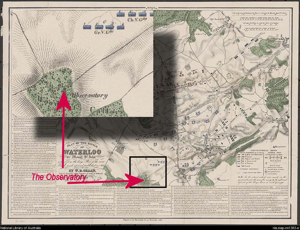
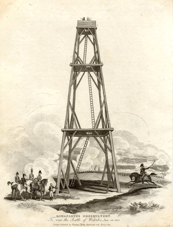
This tower also appears on the map drawn up by the Dutch Surveyor Willem Benjamin Craan in 1816 as the “Observatory” (1) and in Wagner’s maps (2) it’s function is labelled as “telegraph”, which may explain its function as part of an optical telegraph system. The tower is also described as 35 feet tall.
This tower ought to be tactically

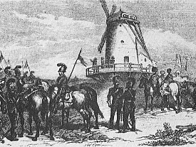
- Extract from Wagner’s Map
significant. One of the ingredients of Wellington’s success was his use of a reverse slope to hide his deployment from the French. But a man standing on the observation tower above the 135m contour would be at an elevation of around 150m, 15m higher than the crest of the Mont St Jean Ridge. This should have enabled Napoleon and Ney to have seen some way down the reverse slope. Obviously once the battle started the visibility would have been obscured by smoke, but before the battle started Napoleon could have had a much better idea of Wellington’s deployment at the start of the battle than many historians would have us believe.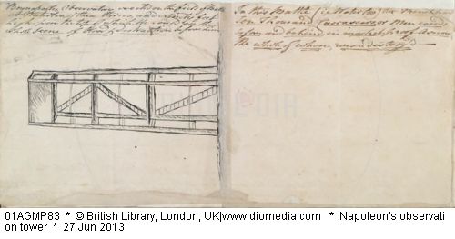
Besides the sketch map in the National Army Museum, there are several documented mentions of the observatory in a manuscript held by the British Library and in the documents published by Booth as a semi official record.(3) The testimony of Jean Baptise De Coster, a local guide for Napoleon mentioned how he did not see Napoleon make any use of the observatory. A foot note to this account mentions that Napoleon had spent an hour up the tower and that it had been constructed by Dutch engineers six weeks before the battle. A British Visitor to the Battlefield of Waterloo on the 16th July 1815 describes, how after dining at the farm of La Belle Alliance, he “Went to the Observatory, it is thirty -six feet high; I nailed on the pinnacle the Royal Arms of Great Britain” (Booth: Additional Particulars: P 121) I recall seeing this tower depicted in a print distributed in the old Battle of Waterloo Jackdaw. It seemed a very fanciful depiction of the battle with an Observation Tower and the trail of rockets like V2s streaking overhead. The tower doesn’t seem to appear in many of the more modern depictions of the battle. It isn’t mentioned in Andrew Uffendall’s “On the fields of Glory” (4) Nor In Atkins’ otherwise excellent Waterloo Companion,(5) although his panorama from the Lion mound does appear to show a mobile phone mast in roughly the same direction, there is no tower on that site now.
There are several un-answered questions about the tower.
Who built it? Was it built by Napoleon’s Sappers? Napoleon did order sappers to build an observation platform for him at Ligny, but pictures show the observation post at Ligny as scaffolding around a windmill. Or was it by the Dutch, as in the footnote to the memoirs published by Booth in 1817?
Is there any evidence that Napoleon made use of the tower, except for the foot note in Booth contradicting De Coster?
What could a French Observer have seen of the Anglo Dutch positions from the Tower?
Why hasn’t this Tower been mentioned in any recent military histories of Waterloo? It made enough of an impact on the British for the Tower to feature in the accounts.
(The origins of this post are in the Waterloo Campaign City Lit Summer School. The class visit to the National Army Museum revealed the sketch map drawn on the battlefield possibly for use during the battle.)
References:
- Craan, W. B. Plan of the battle of Waterloo or Mount St. John [cartographic material] : reduced from the large plan of the same battle, made up and published in 1816
- August Wagner’s Plane der Schlachten und Treffen welche von der preussischen Armee in den Feldzügen der Jahre 1813, 14 und 15 geliefert worden, 4 volumes (Berlin: G. Reimer, 1825.)
- John Booth, The Battle of Waterloo also of Ligny, and Quatre-Bras, described by the series of accounts Published by Authority, with Circumstantial details. By a near Observer. Printed for John Booth 1817 together with “Additional Particulars of the Battle of Waterloo etc” available to download here
- Andrew Uffindell and Michael Corum. On the Fields of Glory: The Battlefields of the 1815 Campaign Greenhill Books, 1991
- Mark Adkin, The Waterloo Companion; Stakpole 2001
